Early in the exploration cycle, the regional geology of large areas needs to be understood in order to effectively direct more expensive techniques. Active (reflection) seismic surveys yield high resolution images but are expensive, environmentally disruptive and impractical to use over wide areas. Passive seismic imaging using easy-to-deploy sensors is inexpensive and has minimal environmental footprint.

Capability Statement – Passive Seismic Mineral Exploration
Ever-increasing financial pressures drive exploration geologists and geophysicists to explore new ways of imaging the subsurface cost-effectively. Early on in the exploration cycle, the regional geology of large areas needs to be understood in order to effectively direct more expensive techniques. Often, deep cover hampers these efforts. Magnetotelluric and other electromagnetic methods are useful for imaging the cover/bedrock contact in some – but not all – situations. Active (reflection) seismic surveys yield high resolution images but are expensive, environmentally disruptive and impractical to use over wide areas. Passive seismic imaging using easy-to-deploy sensors is inexpensive and has minimal environmental footprint.
Passive seismic is the premium method for penetrating the cover that obscures numerous mineral exploration sites
Ambient Noise Surface Wave Tomography
Seismic noise interferometry is a new method gaining use in academic studies over the past decade. Sisprobe’s founders include some of the leading researchers in this burgeoning field. The method is used to accumulate ever-present background vibrations from sources including waves, wind, trains and traffic. The accumulated energy is used to create virtual seismic sources – similar to detonating shots, but without the explosives – which are then used to measure how seismic waves travel through the earth’s subsurface.
This technique – called ambient noise surface wave tomography – is used in the mineral exploration sector to create images (‘snapshots’) of S-wave seismic velocities down to depths of a few kilometers or more. These 3D images are used to map the cover/basement contact and identify major faults and geological structures.
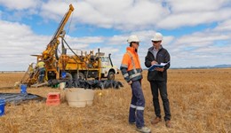
The seismic data is recorded using an array of self-contained nodes with integrated triaxial geophones, GPS receivers, acquisition electronics and battery. The nodes are buried in shallow holes, and typically take a few minutes each to deploy. It’s so easy that Sisprobe encourages exploration teams to collect their own seismic data using rented nodes – an ideal mode of operating in these Covid-19 times!