Passive seismic is the premium method for penetrating the cover that obscures numerous mineral exploration sites. The method uses autonomous geophones at the surface which record ambient seismic noise. No costly and environmentally hazardous active sources are needed. The method can determine cover thickness over large areas – 100 km2 – and determine cover thicknesses to depths from tens of metres to several kilometres. The cost – about USD50 per km2 – is highly competitive with other technique.

Capability Statement – Cover Mapping
Passive seismic is the premium method for penetrating the cover that obscures numerous mineral exploration sites
Alluvium, soil or younger sediments cover large areas  of most continents and obscure vast regions that potentially contain mineral deposits. Geophysical tools provide the best way to penetrate the cover and identify buried targets. Sisprobe’s approach is to use ambient-noise surface wave tomography which is capable of determining the thickness of the cover, the geometry of the basal contact, and structures and lithologies in the younger formations.
The method uses autonomous geophones at the surface which record ambient seismic noise. No costly and environmentally hazardous active sources are needed. The method can determine cover thickness over large areas – 100 km2 – and determine cover thicknesses to depths from tens of metres to several kilometres. The cost – about USD50 per km2 – is highly competitive with other techniques.
Some Recent Results
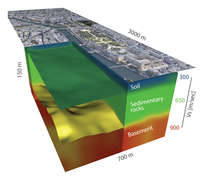
Cover mapping at an industrial site
Closely spaced seismometers (250 m apart, 200 stations)
accurately map the base of cover beneath an industrial site. The mock-up to the right shows our velocity model with clearly identified contacts between soil, sedimentary rocks and basement and also the topography of the basal contact (the view of Paris replaces an image of the industrial site).
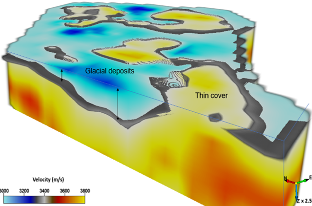
Mapping of glacial deposits in Canada
A dense network of 500 stations deployed over an area 3 x 3 km imaged at high resolution the first 400 m of the subsurface. This survey highlighted rapid changes in the thickness of glacial cover, from less than 50 m to more than 200 m.