
Mineral exploration
Early in the exploration cycle, the regional geology of large areas needs to be understood in order to effectively direct more expensive techniques. Active (reflection) seismic surveys yield high resolution images but are expensive, environmentally disruptive and impractical to use over wide areas. Passive seismic imaging using easy-to-deploy sensors is inexpensive and has minimal environmental footprint.

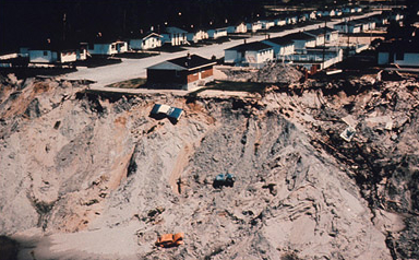

Tailings storage facilities monitoring
Sisprobe, in collaboration with Silixa and HydroResearch offers the capability of monitoring tailings dams and other facilities in real time and in 3D. Using Distributed Acoustic Sensing (DAS) and optical fibres, we can image the entire dam and its foundations and provide immediate warning of internal degradation that may lead to dam failure.

Cover mapping
Passive seismic is the premium method for penetrating the cover that obscures numerous mineral exploration sites. The method uses autonomous geophones at the surface which record ambient seismic noise. No costly and environmentally hazardous active sources are needed. The method can determine cover thickness over large areas – 100 km2 – and determine cover thicknesses to depths from tens of metres to several kilometres. The cost – about USD50 per km2 – is highly competitive with other technique.